Saltwater Disposals (SWDs) are taking a lot of heat for Permian Basin seismic activity. In some circumstances, saltwater injection can interact with geologic fault lines to induce seismicity. But seismicity can also come from hydraulic fracturing or EOR for similar reasons, or mining, or from subsurface hydrocarbon and water depletion, or from natural tectonic activity.
It’s very difficult to attribute any given seismic event to a specific asset or activity, but if your assets have been swept up in a Seismic Response Area (SRA), chances are it’s not your (geologic) fault.
When a seismic event happens near your assets or permits, you need the geology and activity data to defend your assets from seismic event attribution. But it’s not enough to have the data from your own assets – you also need data from all of the other assets and activities in your area. This kind of data is now required for all new SWD permits in the Permian, not just in the SRA.
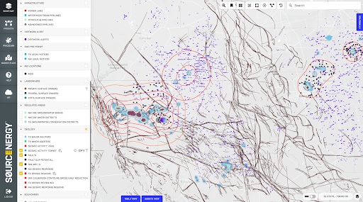
The Sourcenergy screen below shows SRA contours, 3D fault lines, SRA wells, seismic events over 3.0M and daily pinpoint frac locations.

One of the unique data sets we provide is daily pinpoint locations of every frac crew in the Permian. How else could you know if a recent seismic event in your area might have been related to hydraulic fracturing and maybe not your SWD?
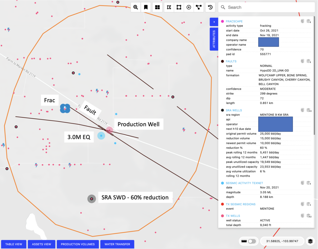
An Example: Why was that SWD cut back? (See image below.)
A 3.0M earthquake occurred in late 2021 in the Northern Culberson-Reeves SRA one day after a 3-week frac job ended 1.25 miles NW. They appear to sit on the same fault line. There is also an active producing oil well .25 miles NE on the same fault. The closest SWD is 1.8 miles due south, but there’s no known fault between the SWD and the earthquake.

That SWD had it’s capacity cut back by 60% under the Northern Culberson-Reeves SRA. But during the several months prior to the nearest quakes, it was injecting almost nothing, and it is a shallow well with a true base depth of 4,800 feet. No other earthquakes over 3.0 have been close to that SWD. But there were six fracs closer to the earthquake than that SWD in the same time period. (Without Sourcenergy real-time frac location data you would never even know about those fracs.)
Should that particular SWD have been cut back by 60%? If you’re the SWD operator it’s probably worth asking.
If you are applying for a new SWD permit anywhere in the Permian or operating an SWD near an area with seismic activity, you need complete seismicity, geology and activity intelligence all in one place. Sourcenergy is the only source for everything you need to make your case.
It’s not your fault!
Contact us for a closer look. Request a personalized demo or send an email to: [email protected]