Pioneering Energy Intelligence
Sourcenergy gathers, analyzes and visualizes surface and subsurface energy and water activity earlier, more completely and more accurately than any other source.
Upstream Energy & Water Intelligence for…

Oilfield Services
Find Opportunities First
Oilfield Services
Find Opportunities First
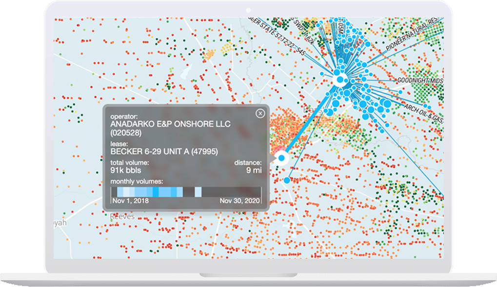
Beat your competition to the next deal with DirtWork Alert™. Patented satellite imagery analytics alert you to new well pads, frac ponds and drilling plans ahead of permit filings and rig movements. We map pre-permit legal notices, permits, rigs, production, pipelines and land. Get daily alerts on drilling and frac plans.

Sourcing
Find Your Best Water Sources
Sourcing
Find Your Best Water Sources
See patented satellite imagery detection of every Permian frac pond, the only commercial water midstream pipeline maps, plus water wells, treatment facilities and other water sources, many with market pricing, so you can always find the best water sources and infrastructure for your next job.

Logistics
Save on Moving Water
Logistics
Save on Moving Water
Water logistics is often the largest LOE. See which leases send water too far or to higher cost disposals when there are closer or better SWDs and water midstream pipelines available. Find frac ponds and water pipelines to save on inbound water. Find logistics savings opportunities to win new business from operators.

Drilling
See Oil, Gas & SWD Drilling Plans First
Drilling
See Oil, Gas & SWD Drilling Plans First
See which operators are preparing to drill oil, gas and disposal wells months ahead of permit filings. Get the earliest notice of potential job bids, offset activity, competition and frac hits.

Disposal
Max ROI for SWDs
Disposal
Max ROI for SWDs
See where to buy or drill disposals and enhance existing assets. Volume, pressure and capacity for every SWD, every month, with true injection intervals and formations. Water flows mapped from O&G wells to commercial SWDs. Disposal pricing. SWD permits, water midstream pipelines, even SWD pre-permit notices from 1,000+ newspapers.

Mineral Buyers
Find Deals First
Mineral Buyers
Find Deals First
DirtWork Alert™ patented satellite imagery detection of well pads and frac ponds shows the earliest and strongest indicators of oilfield activity, plus permits, rigs, wellbores, land and production. DirtWork Time Machine shows surface activity weekly for two years. Patented Pre-Permit Alerts map legal notices from 1,000+ newspapers.

Completions
Optimize Water In & Out
Completions
Optimize Water In & Out
See how much oil, gas and water comes out of and how much water goes into every kind of well to the exact depths and formations. Optimize water sourcing, recycling and disposal with locations and capacities for water wells, frac ponds, water midstream pipelines, recycling facilities, and disposals. See DUCs and fracs.

Recycling
Find the Best Opportunities for Recycling
Recycling
Find the Best Opportunities for Recycling
See who has been or will be producing and flowing back water and where they have been sending it. See where disposal capacity is tight or expensive, so you can spot the best opportunities to treat and recycle water for new completions or offer a disposal alternative.

Geology
Proprietary Subsurface Insights
Geology
Proprietary Subsurface Insights
Get the only commercial stratigraphic mapping of 47 Permian disposal formations, with true depths, formations, injection & production intervals, pressures, porosity and permeability, so you can design the best oil, gas and disposal wells. Proprietary maps of 1,500+ geologic fault lines with daily seismicity updates.
Comprehensive
Data Sources
Unique Geospatial
Tools & Insights
Sourcewater Pro™
Complete oilfield water movement and infrastructure intelligence from source to frac to SWD.


Recent News

“
“Sourcenergy’s innovations in detecting and monitoring key surface activities with AI, satellite imagery and GPS data will extend our edge in the competitive minerals and royalties markets.”
Source: Direct quote
“
“Sourcenergy connects us with the oil
and gas community and with water sellers.
I have found sources of water to recycle and buy with Sourcenergy that I didn’t know were available… saving real money.”
Shell Water Team Leader
Source: E&P Magazine